United States

West Side Highway

West Side Highway

The West Side Highway, also known as the Joe DiMaggio Highway, is a highly acclaimed roadway that stretches along the western edge of Manha…

Best for you if…

  • A 4–5 day trip
  • Sightseeing travelers
  • Cycling travelers
  • Visiting in Summer
Recommended stay
3-5 days
Best time
Summer
Walkability
Moderate
Guide depth
Solid guide
More about this guide

West Side Highway is a strong pick for sightseeing & cycling — plan about 3-5 days. Peak season: Summer.

Solid guide guide · about 5 min to read · depth score 65/100 (coverage of intro, tips, and mapped places)

Moderate density — A mix of walkable clusters with some longer hops. (≈5.1 km span)

5 Places to explore
3-5 Recommended days
Summer Best season
8 Nearby places

Find nearby destinations

When to go

High season: Summer

JAN
FEB
MAR
APR
MAY
JUN
JUL
AUG
SEP
OCT
NOV
DEC

Best months for lower-cost travel: January · February · March · November · December

Weather

Fall

60°F - 80°F

Spring

50°F - 70°F

Summer

70°F - 90°F

Winter

30°F - 50°F

How to get there

How to Reach West Side Highway in the United States

The West Side Highway, officially known as the Joe DiMaggio Highway, is a major north-south route located on the western side of Manhattan in New York City, United States. It offers stunning views of the Hudson River and serves as a vital transportation artery for both locals and tourists. Here's how you can reach the West Side Highway:

By Car:

If you prefer driving, you can easily access the West Side Highway via various entry points:

  • From North: Take the Henry Hudson Parkway southbound until it merges with the West Side Highway.
  • From South: Drive north on the West Side Highway, which begins at Battery Park in Lower Manhattan.
  • From East: Cross over to the west side of Manhattan using any of the major east-west streets and then head towards the West Side Highway.

By Public Transportation:

Public transportation is a convenient option to reach the West Side Highway:

  • Subway: Take the A, C, or E train to the 42nd Street-Port Authority Bus Terminal station. From there, transfer to the M42 bus heading west, which will drop you off near the West Side Highway.
  • Bus: Several bus lines, including M11, M12, M31, and M57, run along or near the West Side Highway. Check the local bus schedules and stops for the most convenient option.
  • Bike: If you enjoy cycling, there are dedicated bike lanes along the West Side Highway. You can rent a bike from various bike-sharing services available in the city.

Points of Interest:

While traveling along the West Side Highway, don't miss these notable attractions:

  • Hudson River Park: This beautiful waterfront park offers recreational activities, sports fields, and stunning views of the river.
  • The Intrepid Sea, Air & Space Museum: Located near the West Side Highway, this museum showcases historic aircraft, submarines, and space shuttles.
  • Chelsea Piers: A sports and entertainment complex with various facilities, including a golf club, ice rink, and fitness center.
  • Riverside Park: Spanning four miles along the Hudson River, this park features scenic paths, playgrounds, and picnic areas.

Whether you choose to drive, take public transportation, or explore the West Side Highway on foot or bike, it's an iconic route that offers breathtaking views and access to numerous attractions. Plan your visit and enjoy the vibrant energy of this bustling highway!

Getting to know West Side Highway

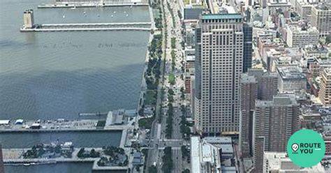
The West Side Highway, also known as the Joe DiMaggio Highway, is a highly acclaimed roadway that stretches along the western edge of Manhattan in New York City, United States. Offering a picturesque route, this iconic highway allows motorists to soak in stunning views of the Hudson River, the majestic New Jersey Palisades, and the Manhattan skyline.

The West Side Highway spans approximately 13 miles, starting from Battery Park in the southern tip of Manhattan and extending all the way up to the Henry Hudson Bridge. It is an essential transportation artery for commuters, as it connects various neighborhoods and important destinations, including the Financial District, Chelsea, Hell's Kitchen, and the George Washington Bridge.

Renowned for its distinct urban charm, the West Side Highway is flanked by a combination of parkland, recreational areas, high-rise buildings, and waterfront spaces. The roadway itself offers multiple lanes, ensuring a smooth flow of traffic and reducing congestion during peak hours.

Aside from its practicality and functionality, the West Side Highway is also a popular recreational destination for locals and tourists alike. With its wide sidewalks and bike lanes, it invites pedestrians and cyclists to enjoy leisurely strolls or engaging bike rides while relishing the tranquility of the surrounding waterfront.

Furthermore, the West Side Highway boasts various access points to famous attractions and landmarks, such as the Intrepid Sea, Air & Space Museum, Chelsea Piers Sports & Entertainment Complex, and Hudson River Park. These attractions add to the highway's appeal, drawing visitors who wish to explore the unique blend of nature and urbanity that this vibrant area offers.

Overall, the West Side Highway provides an unforgettable experience for those who traverse its lanes. By combining functionality with breathtaking views, it has become an emblematic feature of New York City, attracting both locals and tourists who seek to immerse themselves in the beauty and energy of this world-renowned metropolis.

Pre-trip checklist

Compiled from local tips, stay length, and season notes.

Local tips

  • Visit early morning or late evening to avoid crowds
  • Carry sunscreen and water during summer
  • Rent a bike for a scenic ride along the highway

Places worth exploring

5 places mapped for this destination

0–1
1–3
3–8
8–20
20+

Walking loops

Evening strolls, half-days, and fuller day loops — clustered by proximity.

Suggested 3-day outline

Places ordered by proximity into day buckets. Add what you like to your trip.

Frequently asked questions

Answers compiled from stay length, season, and local tips for this guide.

How many days do you need in West Side Highway?

Most travelers spend about 3-5 days in West Side Highway, United States.

When is the best time to visit West Side Highway?

High season is typically Summer.

Which months are more budget-friendly in West Side Highway?

Travelers often find better value in January, February, March, November, December.

What kind of trip is West Side Highway good for?

West Side Highway suits Sightseeing, Cycling, Walking, Picnicking.

Is West Side Highway walkable?

A mix of walkable clusters with some longer hops.

Any local tips for West Side Highway?

Visit early morning or late evening to avoid crowds

Build your trip

Add West Side Highway and the places you want to see — your itinerary stays on this device.

Compare with another place Multi-city routes

Multi-city ideas

Nearby combinations sharing travel styles. See all routes

  • West Side Highway → Longview Heights → West Longview · ≈6 km
  • West Side Highway → West Longview → Longview Heights · ≈8 km
  • West Side Highway → Longview Heights → Kelso · ≈11 km

Same vibe

Destinations sharing travel styles, stay length, or region.

Explore nearby

Nearby places worth adding to your trip

Longview Heights

United States

3.3 km · Best: Summer · 3-5 days · Spread

Longview Heights: A Charming Residential Community in the United States Longview Heights is a picturesque residential community located in…

West Longview

United States

5.7 km · Best: Summer · 3-5 days · Moderate

West Longview is a neighborhood located in Longview, Washington, United States. It is situated on the western side of the city, along the b…

Kelso

United States

6.8 km · Best: Summer · 5-7 days · Moderate

Kelso is a city located in Cowlitz County, Washington, United States. It is situated along the Cowlitz River, about 120 miles south of Seat…

Kalama

United States

20 km · Best: Summer · 7 days · Spread

Kalama is a small city located in Cowlitz County, Washington, United States. Situated along the Columbia River, it has a population of appr…

Clatskanie, United States

United States

23 km · Best: Summer · 3-5 days · Moderate

Located in the United States, Clatskanie is a charming town nestled in the beautiful state of Oregon. Situated along the Columbia River, Cl…

Winlock

United States

35 km · Best: Summer · 3-5 days · Moderate

Winlock is a small town located in the United States. Situated in Lewis County, Washington, Winlock is characterized by its picturesque lan…

Cathlamet

United States

36 km · Best: Summer · 3-5 days · Moderate

Cathlamet is a small town located in Wahkiakum County, Washington, United States. Situated along the banks of the Columbia River, it offers…

La Center

United States

41 km · Best: Summer · 3-5 days · Moderate

La Center is a small town located in Clark County, Washington, United States. It is situated about 20 miles north of Vancouver and is part…